- Home
- ›
- Receivers - OEM
- ›
- AsteRx-i3 S Pro+ GNSS/INS Receiver
Products
AsteRx-i3 S Pro+ GNSS/INS Receiver

Product Information
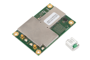
AsteRx-i3 S Pro+ delivers reliable centimeter level positioning combined with 3D orientation in demanding environments. Its sensor fusion provides orientation and positional dead-reckoning, making it ideal for systems that require continuous positioning even during short GNSS outages. AsteRx-i3 S Pro+ allows full flexibility of usage providing raw data and enabling tethered IMU installation precisely at the motion point-of-interest.
IDEAL FOR ANY INTEGRATION
As well as delivering an already integrated position, AsteRx-i3 S Pro+ also provides raw GNSS and IMU data, already synchronised and in a single data stream, for customers that will integrate those components with other sensors for a larger data fusion system (ie lidar). Having GNSS and IMU hardware already integrated and data streams already synchronised enables users to focus on their own core technology without having to integrate GNSS and IMU sensors themselves. The tethered IMU enables the installation of the board where there is more space for it and to install the IMU close to the point of interest with the orientation aligned to the frame of interest.
Dead Reckoning with GNSS/INS
Septentrio’s reliable centimeter-level positioning is based on true multi-frequency, multi-constellation GNSS (GPS, GLONASS, Galileo, BeiDou, QZSS) technology. AsteRx-i3 S Pro+ combines GPS/GNSS and an industry-grade IMU (Inertial Measurement Unit) to deliver precise positioning together with 3D attitude (heading, roll, pitch). Septentrio’s unique GNSS – IMU integration algorithm enables continuous positioning in environments of low satellite visibility where short GNSS outages are possible. This is referred to as dead reckoning or coasting and can happen near high structures, under bridges or under thick foliage. This makes AsteRx-i3 S Pro+ a robust positioning solution for machinery operating in environments challenging for GNSS, such as in container yards, urban canyons or near cliffs.
The GNSS+ Technologies – Top Performance in Challenging Environments
Mechanical vibrations or shocks caused by rough terrain can wreak havoc with satellite tracking. LOCK+ automatically adjusts the parameters of this receiver so you never lose position.
Activity in the ionosphere is a problem for GNSS signals, from loss of RTK fix to total loss of signal lock. Having honed our skills, supporting applications in the most iono-active areas on Earth, the result is IONO+: the most advanced protection against ionospheric disturbances to GNSS signals on any receiver.
Metal and large nearby structures can reflect GNSS signals and produce multipath. The APME+ system effectively disentangles direct and reflected signals enhancing both position and measurement quality. APME+ is bias free and, in line with Septentrio’s commitment to maximum configurability, can be disabled.
Advanced Receiver Autonomous Integrity Monitoring (RAIM+) comprises fault detection mechanisms of the receiver at all the levels including the generation of measurements, quality control and navigation algorithms. Detected faulty measurements, which are typically caused by high multipath or active ionosphere, are removed from the solution.
Anti-Jamming and RF Spectrum Monitoring System (AIM+)
AIM+ offers built-in protection against intentional and unintentional jamming using a sophisticated system of sampling and mitigation mechanisms. Your high-precision GNSS receiver can automatically suppress the widest variety of interferers from simple continuous narrow-band signals to the more complex wide band and pulsed transmitters as well as lnmarsat and Iridium satellite transmissions.
This receiver includes an intuitive web user interface for easy operation and monitoring allowing you to control the receiver from any mobile device or computer. The web interface also uses easy-to-read quality indicators ideal to monitor the receiver operation during the job at hand.
Key Features
- Reliable and accurate IMU-enhanced GNSS positioning down to the centimeter level
- Full access to raw GNSS and IMU data
- Tethered IMU installation with pitch and roll data
- Lightweight, low-power and compact
- Heading available immediately from initialization with dual antenna configuration
- Lightweight, low power and compact
- AIM+ unique interference monitoring and mitigation system + advanced other GNSS+ algorithms
Key Application Markets
- Machine Control
- Logistics
- Robotics
- Autonomous
